Krzysztof Jung
Russia 917–1951
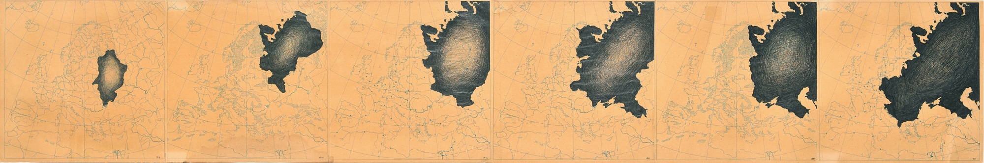
Russia 917–1951 presents the history of territorial development of Russian state. To recreate and visualize this history, the artist used school maps on which he marked the expansion of the Russian state on European territories throughout the millennium. The borders of Russia marked on the first map in 917 actually refer to Kievan Rus, which was later absorbed by the Principality of Moscow.
The expansion of the Russian Empire towards the west took place through the partitions of the lands of the neighbouring countries (these countries were the Republic of Poland, Latvia, Lithuania, Estonia, Finland) and following 1945, the subordination of territories of countries the Soviet troops entered during World War II, which is shown on the last map from 1951 – the year of the artist’s birth.
In showing the territory of the European part of Russia, Jung seems to warn against the invasive and aggressive nature of this state. It visualises the transformation of a small territory into a vast, predatory entity. As a result, it raises the difficult question of what kind of geopolitics can be the most beneficial for our geographical region.
Krzysztof Jung was a painter, graphic artist, performer, creator of the concept of “art theatre” and a teacher. In 1976, he graduated from the Faculty of Interior Design at the Academy of Fine Arts in Warsaw. He was associated with the Repassage gallery, which he ran in the late 1970s.